
Geotab Investigations is a new incident management system integrated into MyGeotab that helps fleet managers investigate accidents by collecting evidence, managing cases in structured workflows, and using AI collision detection to determine impact severity and direction. The system consolidates discovery, evidence, and case management into one platform while supporting integration with insurance providers for faster claims processing.
- Geotab Investigations was announced on August 11, 2026 as a structured incident management system within MyGeotab fleet management software.
- The system uses AI collision detection models and accelerometer data to pinpoint collision location, estimate physical force, and determine impact direction and severity.
- Users can build comprehensive case files containing vehicle activity, notes, photos, emails, police reports, and dashcam footage in a single workflow.
- Data is end-to-end encrypted from vehicle to servers with role-based access controls (View Only, Create/Edit, Admin) and complete audit logging with timestamps.
- Geotab is developing API integrations with insurance providers to programmatically push incident data and accelerate First Notice of Loss (FNOL) processing.
Canadian technology company Geotab has announced the release of Geotab Investigations, a structured incident management system in MyGeotab, the company’s web-based fleet management application for Geotab devices, users and vehicles.
The Oakville, Ont.-headquartered telematics and fleet management solutions manufacturer originally launched MyGeotab in 2012, followed by the release of the MyGeotab mobile app in 2016.
Geotab Investigations was announced on Aug. 11, 2026, and provides users with the capability to understand what happened during an accident by collecting related evidence and managing the investigation process within a structured case workflow, eliminating the need to gather evidence from multiple systems and external platforms. It also monitors driver behaviour, including harsh acceleration, braking, cornering, seatbelt usage and collision detection, Colin Bowers, senior product manager at Geotab, told Collision Repair.
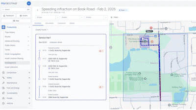
The new feature gathers discovery, evidence and case management into a single workflow within MyGeotab, the company’s press release reported. Users can search for specific locations and timeframes to understand what occurred in an area and can take any initial Area of Activity search and convert it into a structured investigation case. According to Geotab, users can also build case files containing vehicle activity, notes, photos, emails, police reports and dashcam footage.
Geotab’s AI collision detection models pinpoint where a collision occurred and use accelerometer data to estimate the physical force applied to the vehicle, indicating the relative severity of vehicle damage and the direction of impact before the vehicle reaches a repair facility.
Geotab is working with estimating and claims-management providers to make incident data available within existing repair workflows, Bowers reported.
“There are opportunities to develop integrations with insurance providers directly to programmatically push this data via API, which would greatly simplify and accelerate the process for initiating First Notice of Loss (FNOL),” he said.
Geotab Investigations will soon include the ability to download reports as PDFs, which can then be sent to insurance providers, law enforcement and other third parties. The data recorded in Geotab Investigations may play a role in repair planning after future enhancements collect additional details and present them in a way that attempts to reconstruct an accident or other incidents. Additional details collected in these updates could include the direction and speed of impact, weather and road conditions and events leading up to the incident.
Users can create and manage dedicated investigation cases, track investigations through Open, Closed, and Archived lifecycle stages and control access to sensitive investigations with role-based access controls, the company’s press release noted.
A customer’s settings on data retention policies determine how long collision-related vehicle data is retained. According to Bowers, Geotab Investigations is controlled behind three clearances, including View Only, Create or Edit and Admin, and users must have at least one of these specific clearances to have any access to the solution.
Telematics data is end-to-end encrypted from the vehicle to Geotab’s servers and validated upon ingestion. “All user activity in MyGeotab is logged with a timestamp and user stamp, and audit log data cannot be altered or removed,” said Bowers. “In the case that a device loses power or service, the data is stored locally and can be retrieved from the device once power or connectivity is restored.”
To learn more about the new Geotab Investigations feature, visit https://www.geotab.com/fleet-management-solutions/fleet-safety/