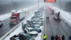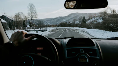

Canada's most dangerous winter roads are concentrated in mountain passes, lake-effect corridors, and high-volume urban areas, with Erieau Road in Ontario topping the list at a crash rate nearly six times higher than other hazardous segments due to lake-effect snow, tight curves, and narrow two-lane conditions.
- Erieau Road (Ontario) has the highest winter crash rate at 0.143 per million kilometres—nearly six times higher than other top contenders.
- Top hazards include lake-effect snow, mountain passes, steep grades, avalanche zones, and wildlife crossings across the country's most dangerous segments.
- The analysis covered billions of kilometres of Canadian driving data from 2022 to 2025, identifying 10 critical crash hotspots.
- High-risk corridors span Ontario, British Columbia, and Alberta, from rural two-lane highways to complex urban interchanges like Highway 401 in Toronto.
- Winter repair shops report 25 percent increased business in the month following first snowfall as drivers adjust to hazardous conditions.
Toronto, Ontario -- Canada’s winter roads carry significantly elevated crash risks, with the most hazardous sections clustered along mountain passes, lake-effect corridors and high-volume urban connectors, according to a new analysis from technology provider Samsara.
The report, based on crash data covering billions of kilometres of Canadian driving between 2022 and 2025, identifies the top 10 winter “hotspot” road segments where crash rates per million kilometres were highest. These sections span from narrow rural corridors to complex urban highway junctions.
At the top of the list is Erieau Road on the Erieau Peninsula in Ontario, where lake-effect snow, tight curves and narrow two-lane roads contribute to a winter crash rate of 0.143 per million kilometres — nearly six times higher than other contenders.
“We always get busier in the wintertime,” said Jonathan Spencer, estimator and technician at Fix Auto Chatham, near Erieau Road. “For a month after the first snow fall, it gets about 25 percent busier than normal before people realize they need to slow down on the roads”
The top 10 most dangerous roads are:
- Erieau Road – Erieau Peninsula (ON): lake-effect snow and shoreline curves.
- Trans-Canada Highway – Rogers Pass/Yoho National Park (BC): steep grades and avalanche zones.
- Trans-Canada Highway – Banff–Lake Louise (AB/BC border): heavy mixed traffic and rapid weather shifts.
- Yellowhead Highway – Jasper–Hinton (AB): wildlife crossings and fast-changing mountain weather.
- Yellowhead Highway – McBride–Tête Jaune Cache (BC): narrow mountain valley conditions.
- Highway 17 – Kenora–Dryden (ON): long two-lane stretches through dense moose habitat.
- Highway 11 – Hearst–Kapuskasing (ON): extreme cold, limited lighting and wildlife exposure.
- Queen Elizabeth Way – Burlington Skyway (ON): crosswinds and elevated bridge exposure.
- Highway 401 – Mississauga interchange complex (ON): dense traffic, weaving and winter refreeze zones.
- Highway 401 Express/Collectors – Toronto core (ON): intense urban traffic, spray and quick refreeze on overpasses.
Samsara is a provider of telematics and connected-operations technology, offering GPS tracking, AI-enabled cameras and cloud-based analytics to help monitor vehicles, coach drivers and improve safety and efficiency. The company’s tools are used by commercial fleets to gain real-time insight into operations and driving behaviour.